| Title of Project/Resource | Recharge site assessment through the integration of surface geophysics and cone penetrometer testing |
|---|---|
| Resource Author(s) |
|
| Link to Report/Website | wiley.com |
| Full Description Text Body | Paper Abstract: The ability to identify, at potential managed aquifer recharge sites, the presence of connected pathways of hydraulically conductive sediments from the ground surface to the water table could help minimize costs and risks associated with recharge operations. A spatially dense dataset had previously been acquired in an almond [Prunus dulcis (Mill.) D.A. Webb] grove in Tulare, CA, using tTEM, a towed transient electromagnetic (tTEM) geophysical method. In order to interpret reliable information about sediment type from the tTEM data, a transform from the tTEM-derived property, electrical resistivity, to sediment type is required. The uncertainty associated with derived models of sediment type can be significantly reduced if a site- and dataset-specific transform is used. Cone penetrometer testing (CPT) was conducted at five locations, strategically selected based on a review of the tTEM data. Co-located measurements of sediment type, derived from the CPT, and electrical resistivity, derived from the tTEM data, were used to create a resistivity-to-sediment-type transform, with sediment type classified as either coarse-grain-dominated (sand and gravel) or fine-grain-dominated (silt and clay) material. The transform captured the uncertainty associated with variable water salinity and content, the resolution of the tTEM data, and other components of the tTEM measurement workflow. Using this transform, models of sediment type were generated for the unsaturated zone at the site. Within these models are features, which we interpret as potential recharge pathways, corresponding to high fractions of coarse-grain-dominated material amongst regions of fine-grain-dominated material. The workflow developed at this site can provide a framework for using tTEM and CPT for recharge site assessment. |
| Featured Image for Display | 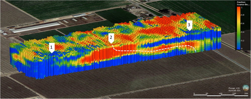 |
| Featured Image Credit | Goebel and Knight, 2021 |
| Topic Area(s) |
|